Tuesday, 9 September 2014

Avila, Segovia and a little around Madrid


Hello and welcome to the next installment of Traveling with the Findlaters. 
In this episode we visit Avila for a medieval market festival and then onto Segovia to see one if its famous landmarks.
Towards the end of the adventure we headed into Madrid to celebrate my aunty's birthday and finished it off with a cycle down the river side.
***

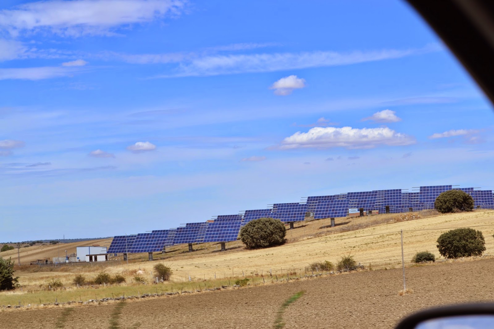

But first a comment: The image above and to the right are of the giant wind turbines that seem to cover the ridges of the hills and mountains throughout the inner road areas of Spain.                                                                                                                               The image to the bottom right  are of what appears to be a solar farm in the unused farmlands of inner Spain.                                                                                                        Overall 23% of Spain's electricity was generated from wind and solar in 2010.                                                                 Spain has set the target of generating 92% of its energy needs from renewable energy sources.                                                                                                                         Spain is the world's third biggest producer of wind power, after the United States and Germany, with an installed capacity of 20,661
.

First up Avila.
 
Avila is notable for having complete and prominent medieval town walls, built in the Romanesque style.  

It is sometimes called the Town of Stones and Saints, and it claims that it is one of the towns with the highest number of Romanesque and Gothic churches (and bars and restaurants) per capita in Spain. 

Below are a series of photographs of birds that were on display for the Medieval Market. What start off as being a novel thing (despite my disagreements on the topic of caged or restrained animals) soon turned into something of an animal well fair issue as completely nocturnal birds were tied to posts in full sunlight in the middle of the day. 


I obviously kicked up a stink to anyone who would listen and could help the birds,
Kyran dragged me away before anything could escalate further. 
Needless to say i was not impressed. 

But moving on! 


 Tickets to climb the wall that surrounds Avila were 5 euros each and as we were limited by time this seemed like a good way to get a good scope of Avila while learning it's history and see its views.

The walls of Avila
 
The work was started in 1090 but most of the walls appear to have been rebuilt in the 12th century. 

The enclosed area is an irregular rectangle of 31 hectares with a perimeter of some 2,516 meters, including 88 semicircular towers. 

The walls have an average breadth of 3 metres and an average height of 12 metres. 

The nine gates were completed over several different periods.


These fortifications are the most complete in Spain.


Some of the sights around Avila


To the right: a medieval obstical  course for children that can be seen in the back ground dressed as horses. 


SEGOVIA


Segovia was first recorded as a Celtic possession, with control eventually transferring into the hands of the Romans.

During the Roman period the settlement belonged to one of numerous contemporary Latin convents. It is believed that the city was abandoned after the Islamic invasion 
of Spain centuries later.

Segovia's position on trading routes made it an important center of trade in wool and textiles.

The end of the Middle Ages saw something of a golden age for Segovia, with a growing Jewish population and the creation of a foundation for a powerful cloth industry.  
In 1764, the Royal School of Artillery, the first military academy in Spain, was opened.  

In 1985 the old city of Segovia and its Aqueduct were declared World Heritage by UNESCO 


The Aqueduct of Segovia (or more precisely, the aqueduct bridge) is a Roman aqueduct and one of the most significant and best-preserved ancient monuments left on the Iberian Peninsula. 

The actual date of the Aqueduct's construction has always been considered a mystery although it was thought to have been during the 1st century AD,


The aqueduct transports water from Fuente Fría river, situated in the nearby mountains, some 17 km (11 mi) from the city in a region known as La Acebeda. It runs another 15 km (9.3 mi) before arriving in the city.

The water is first gathered in a tank known as El Caserón (or Big House), and is then led through a channel to a second tower known as the Casa de Aguas (or Waterhouse). There it is naturally decanted and sand settles out before the water continues its route.

At its tallest, the aqueduct reaches a height of 28.5 m (93 ft 6 in), including nearly 6 m (19 ft 8 in) of foundation. There are both single and double arches supported by pillars. From the point the aqueduct enters the city until it reaches Plaza de Díaz Sanz, it includes 75 single arches and 44 double arches (or 88 arches when counted individually), followed by four single arches, totalling 167 arches in all.

The construction of the aqueduct follows the principles laid out by Vitruvius as he describes in his De Architectura published in the mid-first century.


As the photo suggests we also visited the cathedral of Segovia.

It is located in the main square of the city, the Plaza Mayor, and is dedicated to the Virgin Mary. 

 The Cathedral of Segovia is one of last Gothic cathedrals built in Spain and Europe. It was built in the mid-sixteenth century, when in most of Europe, Renaissance architecture it was the new reference.


 Left: What happens when choir boys eat to much


Below: Some final images from Segovia


Birthday celebrations took us into Madrid on Sunday and ended with a crazy fun filled ride along the banks of the highly regarded Rio Manzanares. below are the resulting photos
.


That brings us to the end of another episode, sorry it was a bit rushed but I hope you get the idea. 

The next Blog will be brought to you by Kyran from Milan (Sorry if it's a bit too nerdy!)

***

Just a quick shout out to my Nan who I hear is the next biggest fan of this blog!


Monday, 1 September 2014

Adventures and near death Experiences


Well guys it's that time again!

Time to update you all on what has been going down in the lives of the Findlaters on our amazing travels abroad.

 This blog is still brought to you from Spain and in the greater regions of Madrid.
As you all know I managed to score a job over here during a time of great financial crisis... at least that's what they call it. 

So the adventures that are brought to you are the adventures that occur on the weekends. 

As you will come to understand the reason that the Blogs are being posted so late is that after the long and arduous adventures I have no energy or desire to leave the bed let alone post the blog for you guys. 

But better late then never right!?

First up is Saturday: A visit to the Spanish Dictator Franco's tomb in the Valle De Los Caidos (valley of the fallen) and a quick visit to the Escorial. Here comes the information and the photos!!

El Escorial
The Royal Site of San Lorenzo de El Escorial is a historical residence of the King of Spain, in the town of San Lorenzo de El Escorial, about 45km northwest of the capital, Madrid. It is one of the Spanish royal sites and functions as a monastery, royal palace, museum, and school.

El Escorial was once a monastery and a Spanish royal palace. Originally a property of the Hieronymite monks, it is now a monastery of the Order of Saint Augustine.


King Philip II of Spain, reacting to the Protestant Reformation sweeping through Europe during the 16th century, devoted much of his lengthy reign (1556–1598) and much of his seemingly inexhaustible supply of New World gold to stemming the Protestant tide. 


 Franco's tomb and the Valle De Los Caidos


The Valle de los Caídos ( "Valley of the Fallen") is a Catholic basilica and a monumental memorial in the municipality of San Lorenzo de El Escorial, erected at Cuelgamuros Valley in the Sierra de Guadarrama, near Madrid, conceived by Spanish general Francisco Franco to honour and bury those who fell during the Spanish Civil War. 

The Valley of the Fallen, as a surviving monument of Franco's rule, and its Catholic basilica are controversial partly because 10% of the construction workforce consisted of convicts, some of whom were Popular Front political prisoners.

The monument precinct covers over 3,360 acres (13.6 km2) of Mediterranean woodlands and granite boulders on the Sierra de Guadarrama hills, more than 3,000 feet (910 m) above sea level and includes a Basilica, a Benedictine Abbey, a guest house, the Valley, and the Juanelos — four cylindrical monoliths dating from the 16th century. The most prominent feature of the monument is the towering 150-metre-high (500 ft) cross erected over a granite outcrop 150 meters over the basilica esplanade and visible from over 32 km away.


Before his death, nobody had expected that Franco would be buried in the Valley. Moreover, the grave had to be excavated and prepared within two days, forcing last minute changes in the plumbing system of the Basilica. Unlike the fallen of the Civil War who were laid to rest in the valley exterior to the basilica, Franco was buried inside the church. His grave is marked by a simple tombstone engraved with just his Christian name and first surname, on the choir side of the main high altar (between the altar and the apse of the Church; behind the altar, from the perspective of a person standing at the main door). We managed to get a picture of it, just above this wall of text!

FRANCO
So who is Franco and why am I carrying on about him so much? Well!

Francisco Franco Bahamonde ( 4 December 1892 – 20 November 1975) was the dictator of Spain from 1939 to his death in 1975. Coming from a military background, he became the youngest general in Europe in the 1920s.

A conservative, he was shocked when the monarchy was removed and replaced with a democratic republic in 1931. With the 1936 elections, the conservatives fell and the leftist Popular Front came to power. Looking to overthrow the republic, Franco and other generals staged a partially successful coup, which started the Spanish Civil War. With the death of the other generals, Franco quickly became his faction's only leader.

Franco received military support from local fascist, monarchist and right-wing groups, and also from Hitler's Nazi Germany and Mussolini's Fascist Italy. Leaving half a million dead, the war was eventually won by Franco in 1939. He established an autocratic dictatorship, Francoist Spain, which he defined as a totalitarian state, installing himself as head of state and government, with one legal political party: a merger of the monarchist party and the fascist party which had helped him.

Franco established a repression which was characterized by concentration camps, forced labor and executions, mostly against political and ideological enemies, being estimated to have caused from about 200,000 and up to 400,000 deaths.

After ruling for nearly forty years, Franco died in 1975. He had restored the monarchy and left King Juan Carlos I as his successor. Juan Carlos led the transition to democracy, leaving Spain with its current political system.
***

WOAH!!! that was a lot of information ... but now you know!

COMING UP NEXT... Sunday's episode of 'NEAR DEATH EXPERIENCES'


La Maliciosa

Maliciosa (meaning malice or malicious) is one of the most important and high mountains of the Sierra de Guadarrama, with an altitude of 2,227 meters above sea level. 

It is located in the northwest of the Community of Madrid, rising from Pedriza, which is to the east, and the valley of the Canyon, which is on its west side.

I mean the name should have given up a clue, stupid horrible mountain... I mean it was lovely and all don't get me wrong and as you can see by the photo on the right we started the day off all nice and early. We began climbing the mountain by 7am with the idea that it was going to be a two hour climb to the top and another two hours back to the bottom, and we would be home by lunch time to swim in the pool and bask in the sun. 

When we got there it was so cold Kyran resorted to warming his hands in his pants, or so he insisted.  
 

On the slopes of Malice predominantly low shrublands, although there are covered areas of Scots pine. Much of this mountain is within the Regional Park of the High Basin of the Manzanares and within the National Park of Guadarrama.

I mean even wikipedia agees with my dignosis of the mountain.
"Originally, this peak was known as the "Mountain Malicious'. This is due to the difficulty has its rise, except for its northern slope. It has a fairly rugged terrain and there is a cumulative altitude higher than 1,100 meters"


By the time I was taking this photo a was already recovering from what seemed like my third heart attack, as we were so out of shape and we were only 30 minutes into our climb.


What ever Kyran was thinking when I took this photo was nothing to what he would be left thinking by the time we reached the top and even the absence of normal human thought by the time we reached the bottom and all survival instincts had kicked in.
  

Beautiful isn't it? they say that the view makes it all worth it, well this in not even halfway up and it's too soon to be saying any of it was worth it.

 
At the beginning there were many photos and much rock gazing, there seem to be a fair amount of good examples of cross cutting and indication of slow and fast cooling of magma and possibly lava.

The principle of cross-cutting relationships states that an igneous intrusion is always younger than the rock it cuts across. 


Here's a couple of photos for you to enjoy from the comfort of where ever you are with water and temperature control at your convenience.


Well guys now this is the view from the top and the photo below is the summit!!
From one day after, while I'm still sore and having horror mountain flash-backs I'm going to go with: I don't know if it was worth it!


To the left is one of the many possible ways we could have died... this unfortunate mountain goat was pinned down by falling rocked and here is were we found it's remains.

Other ways we might have died, i here you ask..?

Well i shall tell you!
1. Falling - steep slopes saw Kyran fall and only just managing to catch himself leaving a variety of scratches and bruises. 
2. Exhaustion - I was rooted! Pretty sure Kyran and I were close to this type of death.
3. Dehydration - we ran out of water at the top and by the time we reach the bottom the creek began to look inviting.
4. Shitting myself to death - from drinking the water that looked so inviting.
5. Sun exposure on the bare slopes of Mount Malicious! We were super lucky that we had an early start, and then very soon after heading down the slope the sky became overcast - saving us from this obvious and rapid death.


Again the remains of one of the locals!


Below are also a bunch of photos from some of the locals that are still alive... for the time being. 


In total I believe that we were hiking for approximately 9 hours. We left home at 6:30 in the morning and didn't arrive back till about 5 in the afternoon.
At which point we collapsed in in moaning piles of pain and pulsating agony in bed.


Well that the last of the adventure photos but for one last laugh here are some photos of a traumatic experience that i just under went!!


 Vitamin B12 injections!!


Under the supervised instructions of a doctor and a nurse of course... i must say though he did it very good in the end... i didn't feel a thing.


Well that's all folks over and out
***